Saturday 29 March 2008

First impressions of New Zealand's South Island

It's big and it's untamed. And so little inhabitation. So few people, you can easily feel you are the only people around for miles.
I didn't think I would ever say this - but driving in the car is a pleasure. We drove round for 4 days on the west side of South Island without seeing a set of traffic lights. At the same time, the views from the car window were dramatic.
Epic scenery on a vast scale - imagine England's Lake District but expanded to the size of the UK. Carolyn and I had memories of South Africa's Southern Cape when we did the Garden Route with Mum/Gwen).

(below: snow covered mountains from th coast road)

(below: watching blocks of ice being swept down the Franz Josef river after falling off the glacier).

Close encounter with a kiwi

Let me tell you about the picture above. We had just arrived at Hokitika that afternoon, and after a quick wander around, I suggested taking the car to a lake and a waterfall, which looked on the map to be a few miles out of town. 20 minutes of driving later and no sign of the lake. I had misread the scale of the map. Still, we persevered and finally reached the lake. Impressive, with wooded mountains looking down. We drove on to the waterfall, but after a little way, the road disappeared and became a dirt track. We pressed on (it was a rental car, rather than our own). Eventually we found the waterfall. Time was now getting on, and the light is a bit gloomy, but decided to walk through a short wooded track down to the lake edge.

It was on the way down to the lake that we saw a kiwi. This ball of fluff with a long beak suddenly walked across the track in front of us. It was half way across when it realized that we were there, and head down, walked quickly to the other side and disappeared into the undergrowth.

The lake view was magical - that still moment before dusk, the only sound the qentle lapping of the waves on the shore. We probably had the lake and surrounding mountains to ourselves. Happy, and with the camera's photo reserves seriously depleted, we headed home.

Thursday 27 March 2008

The Pacific tectonic plate

The Earth's surface is made up of a series of large plates like pieces of a giant jigsaw puzzle. These plates are called tectonic plates. We have been talking about volcanoes and earthquakes and mountains throughout this blog - the reason why there is a lot of activity in New Zealand is because two tectonic plates meet along the island:

The Southern Alps on the South Island are formed by tectonic uplifting and pressure as the Pacific and Australia-Indian plates collide along the island's western coast. The uplifting continues, raising the mountain range an average of 7 mm (just over a quarter of an inch) each year. However, erosive forces are also constant shapers of the mountains. Wind, rain (and ice!) and dramatic changes in temperature are reducing the mountains by about the same amount.

The Southern Alps has the highest mountain in NZ, Mount Cook, which stands at 3,754 metres (12,316 ft). (And, as a powerful example of the erosion forces at work, Mount Cook was 10 m (33 ft) higher until approximately 10 million cubic metres of rock and ice fell off the northern peak in 1991).
More info available at the
Moorland School website.

Wednesday 26 March 2008

Franz Josef Glacier

A glacier is a very slow moving river of ice. A glacier is formed when snow falls regularly on a mountain and doesn't melt away in the summer. Over many years, the layers of snow are turned into ice by the weight of new snow on top of them, and slowly the ice will move downhill.
What that explanation doesn't suggest, when you first see a glacier, is it's size. We are talking millions and millions of tonnes of ice, filling a valley:

As the ice moves down the valley, it gouges rock and stone from the sides like a cheese-grater. And, when the ice reaches the warmer lower slopes, the rock is dumped when the ice melts. Hills of rocks are formed as the glacier expands and contracts as the climate slowly changes. Glaciers are one 'badass' weapon in Mother Nature's arsenal of erosion forces.

What makes the Franz Josef glacier special is that it descends down a steep valley to almost sea level; there is a short approach road from the main coast road, a ten minute walk and you come to the massive river bed and a view of the glacier. Half an hour scrambling over the riverbed boulders and you are close to the end of the glacier:

The other special thing about the Franz Josef Glacier is that it is very fast moving (for a glacier). Wait a while and you can hear and see a chunk of ice falling off the glacier into the river below.

Planes, trains, and automobiles

After the plane to Christchurch, South Island, and a pleasant afternoon and evening in the town; the next day we were up early to catch the train across the island to Greymouth.

The train is called the Tranz-Alpine and it is the only passenger train service in South Island. It crosses the Southern Alps at Arthur's Pass' at a altitude of 920m. The weather there is always awful, and if you want proof, take a look at the weather now on their weather cam.


]


(left: train crossing a river with extensive river bed)


(left: a picture of the typical mountainous terrain)


At Greymouth we hired a car (a little Toyota Corolla hatchback) and set off for Hokitika, a bigger town about 25 miles south. A bigger town. It had three streets. We fell in love with the place - unpretentious, honest (apart from the jade emporiums) and refreshingly down to earth. Here are a couple of pictures to give a feel of the place:

(above: view from the beach over the Hokitika bungalows towards the Southern Alps - you can just see a snow covered peak in the gap in the clouds).
(below: an atmospheric scene - the roaring Tasman Sea, the beach with drift wood, and the glowering grey clouds rushing across the sky).

Monday 24 March 2008

Leg 4: Auckland to Christchurch: 475 miles

It makes a change not to be changing countries, continents and time zones. Domestic airflight in New Zealand is also a bit of a shock - there is no security, no immigration, everyone is relaxed - I half expected the pilot to shout over the lounge "is everyone ready?" to get going.


Here is a picure of the plane we flew in:


As you can see the front of the plane is damaged - we were walking behind one of the flight crew and could overhear what he was saying to some passengers. Apparently 'young Timmy' had overshot the runaway and had 'just glanced' a building. Everyone was quite pleased, however, since there was a strong chance that Timmy wasn't going to make anything near a landing. And, as you can see, they soon patched up the nose of the plane and we were assured that it would last a few flights. I didn't ask whether 'Timmy' was the pilot or not - I reckoned it was best not to know.

Answer to Geography Quiz No.4

Right, I asked you to add up in long hand the miles we have flown to get to New Zealand. Let me show you how I did it, you check your figures and hopefully we will end up with the same answer.


The secret is to get the numbers you want to add nicely set out so there is no confusion about what position they are in - units, tens, hundreds, etc. Draw a line underneath them, and start with the units column. 8, 6 and 3 add up to 17. Write down the '7' and put the '1' as a carry in the next column, the tens column. Okay, next the tens. 5, 8 and 1 gives 14, remember the carry of 1, so we have 15. Jot down the '5' and the carry of 1 into the hundreds column. You're getting the hang of this now. This technique allows you to add numbers with oodles and oodles of digits (as long as you have a piece of paper big enough) so it is worth knowing about. Now the hundreds column. 3, 3, and 4 is 10, plus the carry of 1 and you have 11. Write down the '1' and the carry '1'. Lastly the thousands. 5, 2 and 6 is 13, plus the carry is 14. There are no more columns to add so we write down the number 14.

We can now see the full result: 14,157 miles. Wow! To go to the opposite side of the world - the seasons are different - the UK is in the grip of winter, New Zealand in the middle of summer; even the stars at night are different and the Moon is upside-down! Home seems a long way away.

The second part of the question was really to test your *understanding* of world geography. If you have messing around with your Google Earth I suspect that you would have a good idea what the answer should be. If it takes 14,157 miles to get right round the world, how far is it *all* the way round (the 'circumference').
to be continued.....

Auckland Harbour Bridge

Well, we were intrigued with the Golden Gate Bridge in San Francisco, it seems only fair that we tell you about the main bridge in Auckland. It is the Auckland Harbour Bridge, built in 1959, originally with four lanes of traffic by Cleveland Bridge & Engineering (USA) and Dorman Long (England). It cost 7,515,840 pounds (including compensation to the ferry companies).

In 1969, due to the rapid increase in road usage, two lane girder clip-on sections were added to each side, doubling the number of lanes from 4 to 8. The sections were manufactured by a Japanese engineering contractor, which lead to the nickname 'Nippon Clip-ons':

(The reason for the greeny shade to the above picture is that it was taken from the top of the Skytower in the city centre). It carries road traffic - the eight-lane motorway that runs north-south through the city (just as Highway 1 runs over the Golden Gate Bridge in San Fran).

Our visit to California seems a long, long time ago, so let's remind ourselves of what the Golden Gate Bridge looks like:


It is a classic suspension bridge design, and the picture, taken from the Marin County Headlands, just shows how long the main span is. The structure of the Auckland Harbour Bridge is very different from the Golden Gate Bridge. It is a box truss design, built for strength rather than flexiblity.
The bridge crosses the Waitemata Harbour (the Pacific Ocean side) taking Highway 1 through Auckland north into the posh surburbs of Devonport:


I have also marked Howick in this satellite image. This is where Ray and Pat live, and when they first arrived nearly 40 years ago, it was a separate town. Now it is just another surburb and Pat was pleased that a new double-carriage way had recently opened to make the traffic easier.

Auckland - City of two harbours

Now this is an interesting bit of trivia about Auckland - its harbours.
The main urban area occupies a narrow isthmus between the Manukau Harbour on the south-west and the Waitemata Harbour on the north-east.

The harbours are on the Tasman Sea and on the Pacific Ocean. It is therefore one of the few cities in the world to have harbours on two separate major bodies of water.
(Actually, I can't think of another city with this feature - there are no cities that stretch across the central american isthmus; no cities are situated on the various capes (where oceans meet); the Baltic Sea/North Sea area would seem promising, but I have failed to find anything. Also within the Mediterranean you would think there must be something - but I cannot think of anything definite. Perhaps Gibaltar fits, if it has a harbour on both the Altantic side and the Mediterranean side).

Thursday 20 March 2008

First Impressions - Auckland

Our first impression of New Zealand is that there are three parts of New Zealand - The City of Auckland, the rest of North Island and South Island.


[left: Location of Auckland city in New Zealand]

Auckland is by far the largest city in New Zealand, with a population of 1.3 million, although the capital of the country is Wellington.

Auckland although a small city by European standards, has all the typical problems - major traffic congestion, especially at rush hour times - high property prices and a (relatively) high cost of living - vast, sprawling suburbs reaching out in all directions (there is no green belt) you would expect.

[below: picture of Auckland city centre from Devonport]
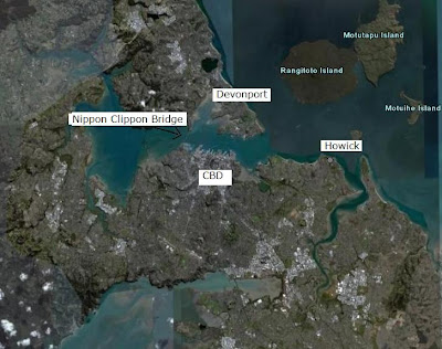
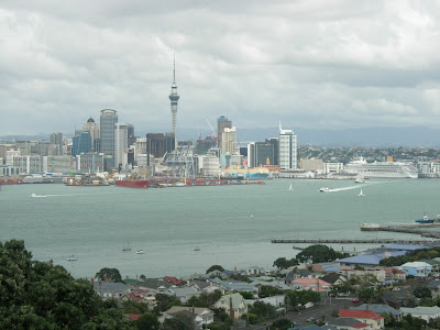
Auckland is a young city - the first house was built in 1840 and, for lack of any other history, has been preserved - and yet Auckland seems to lack the vibrancy and 'get up and go' that you might expect of other cities (I have been comparing with our visits to Berlin and Sydney, which, I suppose, is a little unfair).

Perhaps the reasons for this feeling is that the city drew from the mature culture that founded it (Victorian Britain) or perhaps it is a reflection of New Zealand psyche - simple, hard-working, relaxed, and inherited (or retained) some of the better cultural values from Britain (and not necessarily English - there is a lot of Irish and Scottish decendants here).
But let's be clear - the essence of what is New Zealand will not be found in Auckland - and we look forward to exploring both North Island and South Island to find the real land of the Kiwis.

Wednesday 19 March 2008

Ray and Pat Watkinson

Ray is the younger brother of Dad/Gramps and grew up in Hull after the war along with the rest of the Watkinsons. Then he met Pat and they married.
So far the same story as Dad and Mum (Ted and Gwen). But where they headed south in small steps to better themselves (Northamptonshire, then Hertfordshire, etc) Ray and Pat emigrated to New Zealand, on the other side of the world.
Also, like Dad and Mum, they had four children - Elaine, Nicole, Murray and Neil, and, over the course of time, grand-children and great grandchildren.

Pat has a strong character, organized and efficient, with plenty of energy; and is therefore a perfect match for a Watkinson boy. She has been retired for nearly 10 years now, but is still busy with her golf, extended family and many other things.


Ray is a lot like his elder brother, and it was strange for me to talk to him, because for a lot of the time it felt as if I was speaking to my Dad. Quite spooky at times, and obviously a little emotional. But for all the poignant similarities, there are differences - for instance, Ray quite likes beer and he is useless at car navigation and sense of direction. Pat would have to navigate, and would, of course, feel bound to comment on Ray's drivng as well! When given the instruction for the next turn, Ray would reply "roger" in his best RAF fighter pilot 'cabbage crates over the briny' voice.


We received excellent hospitality and there is a strong sense of family - we thoroughly enjoyed our few days with them.

Tuesday 18 March 2008

O, Where did the years go?

Whether your memory is good or bad you will not forget the long weekend of Pete and Julia's wedding (if you were there, of course). Murray was in the UK at the time, working in London, and was invited down to Tunbridge Wells to join in the celebration.

(Julia, if you're reading this, you did look lovely)

There was a picture taken in the garden of The Shambles of the guests and the photo Murray is holding here is a copy that was sent to Ray and Pat:


It was obvious that Murray had forgotten how many years ago it was, and Laura, his partner was intrigued (or embarassed) to learn that Murray once had a pony tail. On the other hand, I was pleased to show people that I once had black, rather than grey, hair.
So, from left to right, there is Freya, her Mum Nicole (you can see the resemblance in profile), the Man himself, Laura, with Elaine and Matthew trying not to look too interested.

(By the way, if you want to see that photo again yourself, there is a copy on Mum's/Nana's picture wall).

Monday 17 March 2008

The Watkinsons - New Zealand Branch

Ray and Pat (well, Pat, actually) had gathered the clan together at a weeks notice for a family barbeque to greet the representatives from the senior branch (midlands division)!
So, from left to right:

  • Louise (daughter of Laura from her first marriage)(Pay full attention, please, it's not going to get easier)
  • Laura, who is Murray's partner, and is standing in front of
  • Murray (third child, first son, of Ray and Pat).
  • Freya. daugther of Nicole from her first marriage
  • Riley, standing in front of Freya, is second son of Murray and Laura.
  • Nicole, second child of Ray and Pat, is standing behind Freya
  • Matthew, partner of Elaine, standing behind Nicole.
  • Pat, matriarch, one hand on Riley's shoulder, the other on Finn's.
  • Finn, son of Nicole and ex=husband, Mark.
  • Jacob, the little one in the front is the son of Jason and Julie, and great-grandson of Ray and Pat.
  • Olive, family friend of Ray and Pat
  • Reuben, first son of Murray and Laura
  • Geoff, husband of Olive, and family friends of Ray and Pat
  • Me.
  • Carolyn
  • Baby Lucas, son of Jason and sitting on his shoulders.
  • Jason, son of Elaine from her first marriage
  • Julie, wife of Jason
  • Leonie, daughter of Elaine
  • Elaine, eldest of Ray and Pat
  • last but definitely not least, Ray.

Missing from the picture is:

  • Neil, youngest of Ray and Pat, currently in Thailand.
  • Finn, his son who lives with his mum in Australia
  • Rosalie, his daughter who lives with her mum in Austria.

Geography Quiz No.4

Hi, there, Professor Madfish here again. There are two parts to the Quiz Question No.4; firstly :

How many miles have we travelled to visit Uncle Ray and Auntie Pat in New Zealand?

You will need to look up the 3 air flights in this blog, note the miles travelled and then add them up to the total. No calculators please - I want you (whatever your age - we have no ageism here, thank you) to add up the three figures using a pen and paper and longhand addition.

Secondly: with this information, try to guess the circumference of the world (circumference the distance all the way round the earth without changing direction). Will it be more or less than double that of the distance we have travelled? And is the circumference around the equator the same as the circumference around the north and south poles? (Good question, hey!).

Leg 3 : Hawaii to Auckland, via Sydney - 6413 miles

Due to the lack of direct flights, we flew to Auckland, New Zealand from Honolulu, Hawaii via Sydney, Australia:

It was 5071 miles from Honolulu to Sydney, and then another 1342 miles to Auckland.

Time was also a bit messy : we gained 3 hours when we landed in Australia, but then lost 2 of those hours heading east to New Zealand. We also crossed the International Date Line, and so lost 24 hours! We basically didn't have a clue what day it was, never mind the local time!

Saturday 15 March 2008

The biggest mountain in the world

I have already talked about about the outpouring of molten lava from volcanoes to create new mountains, but when that outpouring happens on the ocean floor, then little by little the solidified lava will build up until it reaches the level of the sea, and a new island is formed.

In fact, all the islands in the Hawaiian archipelago have been formed in this way, by a 'hotspot' or weakness in the earth's crust.

The theory is that the tectonic plate beneath much of the Pacific Ocean moves in a northwesterly direction, the hot spot remains stationary, slowly creating new volcanoes. This explains why only volcanoes on the southern half of the islands are currently active.

The tallest volcano, Mauna Kea stands at 13,796 ft (4,205 m) and is taller than Mount Everest if followed to the base of the mountain—on the floor of the Pacific Ocean.

Answer to Geography Question No.3


This was a hard question. I asked is what could the circular feature be in the satellite image below?
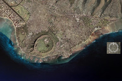
Well, it is a volcanic crater, formed when hot molten rock (called 'lava') is forced though the earth's crust and spills in all directions to create a circular mountain. Earthquakes and explosions of ash and debris are also common with volcanos.
The crater is left after the lava has cooled and slowly the vegetation returns.

This crater is called the Diamond Head Crater and this is a picture of it from where we staying in Honolulu:

Friday 14 March 2008

The USS Arizona Memorial

The reason to stop at Hawaii on our round the world trip was to visit Pearl Harbour. This natural anchorage on the island of Oahu was the place of the surprise Japanese attack on the American Pacific navy fleet, 7th December 1941.

The battleship, USS Arizona, was hit by a bomb which ignited the forward magazine hold and destroyed the ship in one huge explosion. 1,177 men on board at the time were killed.

Today the wreck lies where it sank, still visible just beneath the shallow waters of the harbour, an official war grave. A memorial has been built across (but not touching) the remains of the hull. It is open to the public as part of an organized tour.


The first part of the tour is a 30 minute documentary made from cine archive footage. Astonishingly, the moment when the Arizona explodes is captured on film. It is an incredible, shocking moment. You also see Presdient Roosevelt addressing the nation the next day speaking of the "diabolical act of treachery", and I wondered what the Japanese tourists were feeling at this point.


The audience was quiet when we were lead to the navy launch that would ferry us over to the Memorial. Manned by navy personnel in crisp white uniforms, it was carried out in a dignified, professional manner.
At the Memorial, the atmosphere was sombre, you could see parts of the wreck and there is still oil slowly finding its way from the depths to the surface.

At the far end of the Memorial there are the names of all those killed. I know that the Second World War claimed millions of lives and this was just a miniscule part of that, but you could not help being moved.

Birds of Hawaii: The Brazilian Cardinal

Slightly larger than a sparrow, this bird feeds on small insects and bugs, and also scavenges around tourists and their lunches when possible.
He is rather an attractive fellow; the name obvious from th cardinal red colour of his head ( a cardinal is an important person in the Roman Catholic church and wears a distinctive red hat).
Again, an information board provided the details:

The Mighty Mo

Moored up in Pearl Harbour is the battleship, the USS Missouri. Pride of the Second World War naval fleet, it was on board where Japan signed their surrender documents to end the conflict. Retired in 19xx, it is now a tourist attraction:
The reason for telling you this is that the nickname of the USS Missouri is the 'Mighty Mo'. And, on the spur of the moment, I brought a postcard of said battleship and sent it to Maureen (who, as you know, is called 'Mo') basically saying "I saw this and thought of you".
I hope she sees the funny side of this, because if she doesn't, I am so so dead.

Birds of Hawaii - The Dove

When we first saw these amusing little creatures we thought they were a type of large sparrow - a group of them were twitering excitedly around some food someone had thrown them:
Looking closely, however, their head movement when they walked (rather than hopped) suggested something from the pidgeon family - but the smallest pidgeon we had ever seen.

All was revealed by an information board we came across later in the day - the bird is a Dove; and hopefully you can read the description in the photo.
(By the way, note that it is not the 'Hawaiian Dove' , just 'Dove'; for the same reason we don't call the dove in the UK a 'British Dove').

Tuesday 11 March 2008

Dear Santa

Dear Santa, if I'm a really, really, really good boy, can I have one of these for Christmas????:

The Pacific Ocean is vast!

Flying from San Francisco to the Hawaii islands seemed to take forever, partly because all you could see out of the window was sea. Miles, miles and miles of it. Google Earth proves the point:

In the picture, you can just see the Americas on the right hand edge, and Australia on the left hand; otherwise it's all water!
(By the way, you can also see the archipelago of Hawaii not quite in the middle - we are not even half way across yet!) The Pacific Ocean is big. Really big. Huge. It must be the biggest sea on the planet. What can you learn about it?

Geography Quiz No.3

Right, ready for another geography question? (I hope you are enjoying these questions as much as I am). Here is a satellite image of the area near where we are staying in Hawaii:

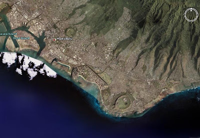
The city of Honolulu is on the left (west) of the image - if you follow the coast line to the right (east) you can see a peculiar circuliar feature on the headland - the question is: what is that feature?


To help you with working out what it could be, here is a picture from the circle towards Honolulu:


It's quite high up, isn't it? So, a good clue for you to think about. Answer in a few days.

Saturday 8 March 2008

Confused in Hawaii

I must admit to being confused about Hawaii and Honolulu - we all know the names, of course, but are they the names of the islands, the cities or the administrative name for the area?
After we got settled in our hotel, a perusal of the available tourist literature quickly cleared up the confusion.


Ok. are you ready?

The archipelago of Hawaii is the 50th state of the United States of America; its capital is Honolulu on the island of Oahu, which is also it's major city.

This state encompasses nearly the entirety of the volcanic Hawaiian Island chain, which is made up of hundreds of islands spread over 1,500 miles (2,400 km). At the southeastern end of the archipelago, the eight "main islands" are (from the northwest to southeast) Niihau, Kauai, Oahu, Molokai, Lanai, Kahoolawe, Maui, and Hawaii. The last is by far the largest, and is often called the "Big Island" to avoid confusion with the state as a whole.

Glad we got that sorted; now are you ready for some trivia?
Hawaii is the only state of the United States that


  • is not located in North America
  • is completely surrounded by water
  • has a royal palace
  • does not have a straight line in its state boundary (must be the trivial of all trivia)

Leg 2 : San Francisco to Hawaii : 2386 miles


Answer to Geography Question No.2

Yes, you have been waiting patiently for the answer; just to remind you of the original question - which bridge in the satellite image below is the famous landmark of San Francisco, the Golden Gate Bridge, Bridge A, B or C?

The answer is Bridge A; connecting the north and south peninsulas that guard the huge bay. The southern side is San Francisco itself; the northern side is the rugged and rural area of Marin County.
The Golden Gate Bridge had the longest suspension bridge span in the world when it was completed in 1937 (1280m; its total length is 2737m) .


When you first see it, the impression is its size, of course, but also its height over the water - it is 227 metres high (746 feet in old money).

Over the four years of construction, 11 workers were killed from falls, even though there was movable safety netting beneath the bridge. Unfortunately, ten were killed when the bridge was near completion when the net failed under the stress of a scaffold that had fallen. Nineteen others who were saved by the net over the course of construction became proud members of the (informal) Halfway to Hell Club.
The bridge has 1.2 million rivets
.

Wednesday 5 March 2008

Rosie the Riveter

Even a country the size of the United States was suffering a manpower shortage in 1943, in the middle of the Second World Two. It was a 'double whammy' effect - men were required in huge numbers for the army, navy and air force yet at the same time it required many more in the armament industries. Typewriter firms built rifles, car makers turned out tanks.

The solution was to encourage women to fill the labour shortage, and when the SS Jeremiah O'Brien was built, in mid 1943, a third of the workforce were women. If the thought of a woman as a welder, a riveter, crane operator or labourer sounds a bit unusual now, it must have been shocking in the 1940s.

To try to persuade women to apply for jobs in the 'manual' trades, they came up with the 'Rosie the Riveter' campaign with the slogan "We can do it" (Rosie looks a bit butch in the poster - perhaps taking a cue from the Soviet revolutionary posters of the 1930s).